
How Climby is Your Climbiest Ride?
I often think about how lucky I am to live where I live. “As a guy who loves riding both road and mountain bikes, and loves riding them in the mountains, I could not have picked a better place to live,” I tell myself.
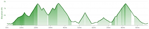
For example, a couple weekends ago, I rode what I call “The Gauntlet Deluxe,” a 97-mile ride with 11,497 feet of climbing. Here’s the elevation profile for that ride:
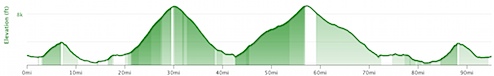
And a few weeks earlier than that, I rode over Suncrest and then up a couple of canyons to a couple of ski resorts and back. That was a 95-mile ride with 11,318 feet of climbing. The elevation profile looks like this:
These are totally different rides, but they have a few things in common:
- They’re right around 100 miles
- They start and end at home
- They’re really, really hard
As I do rides like this, I often think to myself, “Wow, this is really stupid of me, and I am way over my head.”
But when I’m not thinking that, I think to myself that I live in a pretty amazing place for this kind of cycling.
But is it the most amazing place for this kind of riding? Maybe. Maybe not. I really don’t know.
Show Me Whatcha Got
But I’d be interested in finding out what kind of mountainous riding other people have available to them, right out their front door.
So why don’t you show me (or tell me, because I am a very trusting person) what your awesomest out-the-door climbing ride is? And I‘ll give a new FatCyclist jersey to the person with the climbiest ride of all.
Just a few rules.
- The ride must start and end at your home. It can be a loop or an out-and-back.
- The ride must be no more than 100 miles long.
- The ride cannot climb any road or trail more than once.
If you’re the winner, you’ve got to be prepared to prove the ride exists and satisfies the rules. That’s fair, right?
And bonus points if you’ve actually done the ride, have pictures and a story.
This contest ends end of day Tuesday.
PS: “Flatlander Boobie Prize” prize will be given to first person who can demonstrate that there’s no possible way for them to climb more than 100 feet if they satisfy all the satisfy the rules above. What is the “Flatlander Boobie Prize?” I don’t know yet, but I bet it’s cool enough to warrant submitting the entry.
Comment by John juge | 07.30.2012 | 9:05 am
7 Hills of Kirkland… Century Route? Goes right be my house. I could join it there or start from the official start in dt Kirkland. Does it count?
Seems like it should count as an entry since you can start and end it at your house. What’s the distance and elevation? I can’t remember (did it once, but I don’t have record of the amount of climbing. – FC
Comment by NYCCarlos | 07.30.2012 | 9:11 am
I have a feeling nhjoe has a good shot at winning this.
Comment by Bruce | 07.30.2012 | 9:15 am
I can’t a ride near my house that does NOT include a lot of rolling hills. Seems no matter the route, I average 1200 feet of up per hour. Great for the legs…
Comment by Kent Peterson | 07.30.2012 | 9:16 am
This one is pretty hilly but it doesn’t hit any of the big mountains in the area, just the little ones:
http://kentsbike.blogspot.com/2007/09/issaquah-alps-100k.html
I recall some guy named Elden riding it a few years ago when he lived out here.
I remember it, and how thoroughly it kicked my corn. – FC
Comment by NYCCarlos | 07.30.2012 | 9:18 am
also, can I win the boob prize because I live in NYC and it’s nearly impossible to do any kind of
Comment by TMZ | 07.30.2012 | 9:24 am
Flatlander prize submission: Slidell, LA — elevation, 3 feet above sea level. Surrounded by miles of nothing but flat roads. For example, if you head to Hammond, LA (~50 miles away), the elevation changes to 43 feet, so a total out and back of ~80 feet change in 100 miles. And there are no rolling hills, it’s all just flat. It’s the flattest place I’ve ever lived. By a lot. :-)
Comment by Christina | 07.30.2012 | 9:35 am
I won’t win, but I gotta throw out one of our better rides. It’s one of those that gives you a demon profile when you chart the elevation. It’s also typically a headwind going all the way out/up. That means you can scream back into town.
http://www.cheyennecity.org/DocumentCenter/Home/View/5754
Comment by Mark J. in Dallas | 07.30.2012 | 9:41 am
I live in Dallas, therefore I am claiming the early lead in the flatlander boobie prize. What do you need for validation Elden, a GPS (garmin) log and elevation chart? Finally, a contest I can win!!!
Comment by RL Julia | 07.30.2012 | 9:49 am
Flatlander Booby Prize –
I live in Chicago, Illinois where you can practically roll a marble across the state. I have literally taken my kids on field trips to see a hill (I am not kidding). O.K. just to prove my point I looked at the elevation between where I live on the northside of Chicago and Milwaukee, WI (about a 70 mile one-way ride)as well as Elgin, IL (NW), Napeville,IL (SW-ish) and Crown Point Indiana (S/SE).
My house is apparently at 180 ft. above sea level. As you can see none of these ride at their highest points provided me with more than a 100 foot elevation change.
Milwaukee: highest point 225 elevation change of 45ft
Elgin: highest point – 250, elevation change of 70 ft.
Naperville, IL: highest point – 232, elevation change of 52.
Crown Point, IN: highest point -225, elevation change 45 ft.
I used this website to figure all this out: http://googlegeodevelopers.blogspot.com/2010/03/aint-no-mountain-high-enough.html
Comment by Kevin | 07.30.2012 | 9:52 am
I have a few of these I could come up with. Any restrictions on multiple submissions?
This is my go-to training ride. 86 miles, mix of mostly gravel with some mmr’s thrown in to keep it interesting. Around 1200′ climbing according to corrected Strava data. There are few enough “climbs” I made a segment out of the dogs that chase me.
http://app.strava.com/activities/7298253
Comment by Justin L | 07.30.2012 | 9:58 am
This is a regular ride we all do around here, devil mountain aka mt diablo. I have not mapped it but here is someone else map of it. I live in Livermore, so I actually add about 40-50 miles extra to get to and from the ride. Awesome ride with some mice climbing. When the death ride comes around, I will be doing repeats up mt diablo.
Comment by Justin L | 07.30.2012 | 9:58 am
http://www.mapmyride.com/routes/view/462057
Here is that link for visual people
Comment by Papuass | 07.30.2012 | 10:00 am
I do not qualify for a contest, as my country, Latvia offers no such thing as mountains. Our highsest hill is 311 metres high and no one is stupid enough to make a road or bike trail on it. It is used for “alpine” skiing in winter, though.
So we are left with only some 100 metre climbs, very few of them are paved and suitable for roadies. The best from these places is locaeted in a river valley, with 100 and 80 metres climbs on both banks. They call the excersise “swings” and do climbing repeats there. There are a bit more options for XC riders with some steeper, but not much longer sections.
Comment by Nicole S. | 07.30.2012 | 10:10 am
Rist Canyon is the climbiest route in these parts, though cyclists have been voluntarily staying away from it as residents pick up the pieces after the High Park Fire destroyed many homes there (avoiding to make sure we’re not in the way of construction crews, etc). Here’s a Strava profile from last year:
http://app.strava.com/rides/950907
Some day, I’ll woman up and add the south end of this ride, http://app.strava.com/rides/14181725, to add an extra 1250+ feet of climbing.
Others tougher than me will climb all the way to the top of Trail Ridge road (highest continuously paved road in US – tops out over 12000 ft) from Fort Collins, though that’s about 135 miles round trip.
Comment by Hepmike | 07.30.2012 | 10:17 am
Mr. Fat i’d throw my hat in ring by mentioning the Portland (OR) “Ronde”, patterned after the Tour De Flanders. It’s 47 miles, and around 7800 ft. of climbing, including several with grades of + 20 percent. It takes most of the 500 or so riders between 4-5 hours to complete, and yes it sucks pretty bad.
http://www.rondepdx.com/
Comment by ClydeinKS | 07.30.2012 | 10:20 am
Might need an update to the rules for:
1a) refer to rule 1. although must be current residence.
Otherwise, I might be able to challenge @Mark J. in Dallas. Mark, I’ll give you Dallas being flat, but during my longer-than-care-to-remember time in Abilene I could route some rides I took when first returning to the bike, that made my return to the Midwest appreciate a terrain that allows water to flow (or simply trickle).
There are some quite flat areas here in KS, but won’t submit for the Flatlander prize because they don’t compare to other areas I have ridden from my doorstep.
Comment by 7d brian | 07.30.2012 | 10:25 am
You actually saw me doing my climbiest ride ever.
June 21st is summer solstice. I took the day of work to mountain bike ALL day long.
5:45 started at my house in Pleasant Grove rode up to the mouth dry canyon.
1) Up dry canyon
2) Up baldy
3) Down baldy – up timp perimeter road
4) Met wife – timpooneke, ridge, joy, lariat
5) Wife leaves – up to the 4 way again – down tibble
6) Down the the mouth of the canyon to meet daughter
7) Up to the timp cave monument – passed by Fatty & the Hammer. Fatty say “hey you”. I wonder if Fatty thinks it is weird that a mountain biker covered in mud & sweat is riding up the road on AF canyon.
8) Daughter picks me up in the car – drive back up to Timpooneke parkign lote
9) Climb up to Julie Andrews Meadow with daughter.
10) Daughter crashes on ride back down on dirt road. We think she may have broke her arm. The ride ends prematurely at 8:30 pm. Her arm was fine – just bruised.
56 miles – somewhere around 11,500 feet of climbing
I have the garmin track & pictures.
Comment by Chris | 07.30.2012 | 10:27 am
Great timing for this contest. I’m doing a ride with some friends tomorrow that I estimate will be around 130km and somewhere over 10,000 ft of climbing. I’ll let Strava be the judge of the specifics. Probably not a winner, but will hopefully get me on the board.
Comment by 7d brian | 07.30.2012 | 10:28 am
You actually saw me doing my climbiest ride ever.
June 21st is summer solstice. I took the day of work to mountain bike ALL day long.
5:45 started at my house in Pleasant Grove rode up to the mouth dry canyon.
1) Up dry canyon
2) Up baldy
3) Down baldy – up timp perimeter road
4) Met wife – timpooneke, ridge, joy, lariat
5) Wife leaves – up to the 4 way again – down tibble
6) Down the the mouth of the canyon to meet daughter
7) Up to the timp cave monument – passed by Fatty & the Hammer. Fatty say “hey you”. I wonder if Fatty thinks it is weird that a mountain biker covered in mud & sweat is riding up the road on AF canyon.
8) Daughter picks me up in the car – drive back up to Timpooneke parkign lote
9) Climb up to Julie Andrews Meadow with daughter.
10) Daughter crashes on ride back down on dirt road. We think she may have broke her arm. The ride ends prematurely at 8:30 pm. Her arm was fine – just bruised.
56 miles – somewhere around 11,500 feet of climbing
I have the garmin track & pictures.
I technically don’t qualify because
1) I didn’t get back to my home due to my daugher’s crash. However the intent was to ride home.
2) I climbed up to the 4 way twice (however once for joy and once for tibble).
3) I descended Timpooneke road twice.
Comment by Drew | 07.30.2012 | 10:34 am
I moved to Houston from Colorado Springs in April, my out-the-door ride was great: http://goo.gl/QTiHa. Now, my ride is a lot flatter. The highest point in Houston is 125 feet and the highest point in all of Harris County is 310 feet.
Comment by Dell | 07.30.2012 | 10:37 am
Lubbock, TX. Nothing from me. My biggest elevation gain is climbing out of bed to go ride.
Comment by matt mccluskey | 07.30.2012 | 10:37 am
FC,
Here’s one from PA. Short and punchy hills, but a lot of them.
http://app.strava.com/rides/14148161
(Coule be slightly modified in the middle of the “8″ to not re-ride the road to/from a critical/remote gas station for food/water.)
From mile 30 to 65, it hurts. Sure it’s not the Rocky Mountains, but I couldn’t convince any of my riding buddies to go with me, as it was “too hard”.
Comment by Franky | 07.30.2012 | 10:45 am
I can ride a “Tour de Shore” century starting from home and get to climb an amazing 200 ft, ±10 feet. That should count for something.
Comment by Josh K. | 07.30.2012 | 10:45 am
Looks like I’ve been beaten to it, but I’ll throw in another entry for the “Flatlander Booby Prize” – an out & back with a little turnaround loop at the end. Maximum difference of about 50 feet from highest to lowest point. http://www.mapmyride.com/routes/view/119009945
Comment by dan p | 07.30.2012 | 10:52 am
All the toughest climbs in the Berkeley/Oakland area, smooshed into one ride, 68mi rd trip from my place.
http://ridewithgps.com/routes/1515743
Comment by nh_joe | 07.30.2012 | 11:14 am
Just rode this last week! It’s not right from my house because I started in Boulder (40 min drive)
http://app.strava.com/activities/13964025
And two days later (from my house):
http://app.strava.com/activities/14178982
Comment by Skippy | 07.30.2012 | 11:27 am
No idea how long this route is but i do it and you can check with Thomas Rohrregger for grid refs as it is starting in his home village in Austria .
Leaving Kramsack heading east for Worgl, Kufstein & Lofer . Turn south through Zell am See , West through Mittersill and Zell am Ziller , north through to Strass and then east via St Gertraudi to Reith and then home to Kramsach . Incorporated in the route are passes Thun ,Gerlos and a couple of 20% bumps .
Not quite the Giro or TDF but good training nevertheless!
Looking back on the weekend i was pleased to see Taylor Phinney shine and rode with him earlier in the week when i met Davis and Connie .
If taylor rides the Olympic ITT , put money on a Medal !
Comment by Heather | 07.30.2012 | 11:38 am
I do portions of this ride regularly–it’s almost all bike path. While it is quite flat, there is guaranteed to be a strong headwind off of Lake MI–if you didn’t know, West MI is the home of the 4-head winds. Doesn’t matter which direction you’re going, you’re going into the wind.
There is only one hill in our entire county :(
http://www.mapmyrun.com/routes/view/119030551
Comment by Rebeka | 07.30.2012 | 11:57 am
This is a 104.86 mi Bike Ride in Front Royal, VA. We just recently moved here, which is at the end of the skyline drive. This ride has a total ascent of 8,556.43 ft and has a maximum elevation of 3,707.35 ft. I haven’t been brave enough to try it. Maybe in the fall when temps are cooler and I have more training done. Look up skyline drive for more info!
Comment by GenghisKhan | 07.30.2012 | 12:07 pm
Hey Fatty and everyone, kinda related, if my phone is IQ-challenged, what’s a good, inexpensive way to play in Strava-land?
Comment by Pat Schleck (the cyclist formerly known as MattC) | 07.30.2012 | 12:30 pm
If I link these two rides together I’d be right at 100 miles, w/ just around 9500′ of climbing…I must admit I’ve never linked them together (yet..but I’ve thought about it for some time now) but for a chance at a Fatty jersey I surely would!
http://app.strava.com/rides/10445043
http://app.strava.com/rides/10031042
The first one is right from my front door, my ‘usual’ weekend ride…Tepesquet Canyon (light traffic, AWESOME pavement!)
The 2nd one is Figueroa Mt (many of the pro teams use it as a European climb training ride every Jan…back in the Postal/Discovery days Lance and company would be camped in Solvang every year for a few weeks, and this was one of their rides)..it’s a 4500′ 10 mile climb listed as an HC category. It’s a beast.
However I am weak this year and not very worthy…I feel like I’m going slower with each ride. Ever feel like that? (my last Tepesquet ride I managed a new PR…which sadly was my SLOWEST avg spd EVER on this ride).
Comment by Stephanie M | 07.30.2012 | 12:31 pm
Just did the Seattle Century (www.seattlecentury.com) on Saturday. 99 miles with over 5500ft of elevation gain, race report (with requested pictures and story) here:
http://stephsoap.blogspot.com/2012/07/seattle-century-race-report.html
Comment by Pat Schleck (the cyclist formerly known as MattC) | 07.30.2012 | 12:36 pm
@GhengisKahn, you kind of need a Garmin for the Strava uploads…Strava is free…you can get a 200 model pretty cheap…then there is the 500 which is much nicer (between 300 & 400$)…OR you can get an 800 w/ full touch screen (this one has full map capability…but you don’t have to BUY the expenisve Garmin maps…you can get Garmin capable maps for free on the internet)..OR, you can do what I did and get a 705 (which is being discontinued…you might find a pretty good deal on one)…it’s almost the same as the 800 but w/ buttons instead of touch screen…whichever way you go the Garmin is a nice unit, beats my old Polar stuff hands down in every category (sorry Polar).
There’s prob other units that will work w/ Strava..basicly you need a gps type file..it will accept various versions I belive.
Comment by Matt | 07.30.2012 | 12:50 pm
From my front door, hit up both sides of Paris Mtn, out to Caesars Head then to the top Sassafras Mtn and back home. Rolling hills between all the mountains. You come out with 11,000 ft of climbing in 97 miles. http://ridewithgps.com/routes/1516113
Comment by Tonya | 07.30.2012 | 1:00 pm
This will not win but I love this ride from my front door and I do it in some form 5-6 days a week. The ride that has the most climbing heads up Deer Creek Canyon you turn right and head up High Grade and climb some more to the Grange you continue on through City View (up and down) around to Turkey Creek and then you head over to Evergreen and Kittredge and come back. The part of the ride I have done is the 89-mile course of the Deer Creek Challenge which has 10,597 feet of vertical climbing. Most days I alternate between the Climb up Deer Creek out and back (32 miles from door to door) or The Climb up High Grade and the Grange and back (43 miles door to door)–I also love the descent on this one. I love to ride and head out early most mornings on my Specialized Era mountain bike. Yes I do this ride on my mountain bike and most of the roadies think I am crazy but I love to ride and you ride what you’ve got–I also try to incorporate trails like Deer Creek, South Valley, Cathy Johnson Trail and Mt. Falcon into the ride.
Here is the link to the Deer Creek Challenge:
http://www.deercreekchallenge.com/Course-Map.html
Tonya
Comment by Tonya | 07.30.2012 | 1:01 pm
Sorry, I meant left and head up High Grade.
Comment by Matt | 07.30.2012 | 1:07 pm
Climbiest official event I’ve done was this year’s Assault on Mt Mitchell. Leaves from nearby Spartanburg, SC and finishes at the top of Mt Mitchell, the highest point east of the Mississippi. Elevation gain is a little over 10,000 ft and more than half of the climbing is done between miles 80-103. http://app.strava.com/activities/9059899
http://www.freewheelers.info/assaults/assault-on-mount-mitchell.html
Comment by Andrew | 07.30.2012 | 1:10 pm
For the boobie prize, what do you mean by 100 feet? Like a 100 feet in total elevation gain over a ride, or 100 feet of uninterrupted climbing?
Also, does it have to be where we live now, or can it be someplace we’ve lived previously?
Comment by Lori P. | 07.30.2012 | 1:13 pm
Flatlander.
I can go ride my 30 mile-Sunday-morning-in-the country-ride and the only thing between me and miles of vineyards is a freeway overpass.
Probably not flat enough for any kind of prize but my area in the Central Valley (an hour away from where the Davis ride was) is flatter than where I lived in Kansas.
To get to any hills I have to throw the bike in the truck and drive about 45 minutes.
Comment by Ginger-Schminger | 07.30.2012 | 2:00 pm
I don’t know how I’d possibly prove it, but it’s easy to do a long ride in the Lubbock, TX area with little to no climbing at all…without riding the same road twice.
Usually we wind up riding out the the canyon and riding the same hill over and over and over again to get some kind of hill workout!
Comment by Liz | 07.30.2012 | 2:08 pm
I’m betwixt and between. We have rolling terrain, but nothing that would give you that elevation profile. Not flat enough for the boobie prize, either.
Which is all good, because I’m technologically challenged and not sure I could produce adequate proof.
Comment by nh_joe | 07.30.2012 | 2:14 pm
I forgot to mention that I did three days in a row, never hitting the same climb twice, with 32,205 ft of climbing!
13,600 ft – http://app.strava.com/activities/13964025
7,700 ft – http://app.strava.com/activities/14060332
10,800 ft – http://app.strava.com/activities/14178982
Comment by jon | 07.30.2012 | 2:16 pm
Okay, as the 2nd Chicagoan responding, I might be in trouble…
The only way my ride is getting into the mile high club is via American Airlines… (or, another major carrier!)
Even lugging it to the top of the Sears Tower isn’t going to register in the pantheon of FC rides listed above…
Oh well.
Comment by Jeffrey R, | 07.30.2012 | 2:18 pm
Stupidest climbing ride from my house was 5/6 of the Berkeley Death Ride which I dubbed Not Quite Dead Yet. 43.5 miles, 4,550′ of climbing. Short and steep.
http://www.mapmyride.com/routes/view/37311568
I’ve done longer and I’ve done more climbing, but that’s the most climbing per mile on a ride from my house.
Comment by Austin F | 07.30.2012 | 2:38 pm
Ok so here is mine. Yes it does travel some roads out and back but with where I live I have no choice, its the only safe road that I can travel and some of the areas only have 1 road to and from some of the points i travel to. 88+ miles. I climb a total of 535 feet during the entire route, but i don’t get higher than 66 feet above sea level at any point during the ride. And btw, the wind here SUX the life out of you after awhile especially on the beach rides.
http://www.mapmyride.com/routes/view/13146174
Yeehaw to the beach…and I’m moving to Chicago in a few weeks. Joy.
Comment by RL Julia | 07.30.2012 | 2:49 pm
Austin F – welcome to the flatland – although sometimes the wind makes up for the lack of elevation change.
Comment by Pat in Westminster Co | 07.30.2012 | 3:28 pm
How about the Triple Bypass, 120 miles and 11000 ft of climbing, from Evergreen Co to Avon Co over Juniper Pass, Loveland Pass, and Vail Pass. Then just for kicks do it again backwards the next day. They call that the Double Triple. This year it rained both days and the rain sucked the life out of you. But I’ll do it again next year and the next…..
http://app.strava.com/rides/13514370
http://app.strava.com/rides/13387191
Both are missing portions of the route……rain and batteries.
Comment by Steve M | 07.30.2012 | 3:49 pm
For the flatlander prize,is there a minimum distance?
Comment by Fuzz Martin | 07.30.2012 | 4:12 pm
So, this is kind of deceiving because my Garmin apparently wasn’t calculating correctly at the start. This is from out the door of the vacation rental house that I my family and I just rented in Outer Banks, NC. The start elevation is not really 100 feet, but my Garmin thought it was.
This was my 50 mile out-and back:
50 miles and only 301 feet of climbing.
But, my real home is in the rolling hills of WI, so I can neither win the climbiest nor the boobiest of the prizes from my own front door.
Comment by Clydesteve | 07.30.2012 | 4:46 pm
http://veloroutes.org/r/86476
~85 miles, 5943′ raw elevation gain.
But, it is a loop next to the family summer home on the way to Sisters which may disqual?.
I have to ride this http://veloroutes.org/r/86480 to intercept the above loop from my doorstep.
The second route, which is from my doorstep is 65.2 miles, 7422 ft elevation gain (one way), 11% average grade, 27% maximum grade. But as a there & back, i am looking at 130.4 miles, violating Fatty’s completely arbitrary standard of 100 miles.
But, a hard days’s work!
Comment by Clydesteve | 07.30.2012 | 5:35 pm
A loop from my home that is within the parameters set by Fatty: http://veloroutes.org/r/86485 . ~61 miles, 7835 ft elev gain, 30% max grade.
This loop is best done on a CX bike, since some is on gravel roads. I took a church youth group on this as an overnighter once. The other adult chaperones were not amused. They never asked me to plan a church youth group activity again!?!
Comment by Jeremy | 07.30.2012 | 5:40 pm
The Flatlander Boobie is a tough one. A handful of overpasses and you hit 100 ft of elevation gain. Being in the middle of a pretty wide valley, I get to warm up before I get into the foothills so not much climbing here, but more than a Boobie.
Comment by Daniel | 07.30.2012 | 6:30 pm
When I used to live in north Georgia I had plenty of hills to ride and anything over 80 miles would end up being a really hilly climb:
http://app.strava.com/activities/11495250
And all rides were in preparation for this bad boy:
http://app.strava.com/activities/11495318
The infamous Six Gap Century – unfortunately this one is just over 100miles but all of my training rides should count!
I left Georgia a couple of years ago for Nashville – very few hills over 250-300ft in height so my once stellar diesel-piston legs are now floppy old women underarms. It makes me weep :-(
Comment by Paulo | 07.30.2012 | 7:46 pm
Here in the small town o “São Mateus do Sul”, Brazil, we have a mtb track that we call “Perdidos” (it means “Lost”) because we was trying to find an old track behind a shale mine and figure that we was completely after 45km! We have become cycling only few months before and was very tired at this moment, so we begin to try to find someone to help to find a shorter way back, but we was in the middle of nowhere. We finally find a way back home, but rode 59km and climbed 811m. Not bad for beginners at all. Unfortunately I don’t have pictures of it but I have of another track on the same region that we call “Cabeça de Cavalo” (that means “Horse Head”), see boot on my team website (http://www.equipemille.com.br/trilhas-mille). You can see my picture in the same site, look for the bigger bike (and biker!) (I used to weight 130kg!)!
Comment by Sean | 07.30.2012 | 9:15 pm
I’m not quite in shape to do this ride but look forward to getting to that pt http://www.mapmyride.com/s/routes/view/bike-ride-map/pennsylvania/pittsburgh/25730146
Comment by Steve | 07.30.2012 | 9:33 pm
No way would I do all 5 in one month let alone one day
http://coloradotriplecrown.blogspot.com/2012/04/boulder-fearsome-five-los-cinco-diablos.html?m=1
Good luck trying to ride up Magnolia.
Comment by bob | 07.30.2012 | 10:05 pm
@Dell in Lubbock: you forgot the curb!
Comment by Scott | 07.30.2012 | 10:07 pm
I live one mile from the start/finish of the (in)famous Mulholland Challenge course – 113 miles and 13,000+ of climbing. Most people who do this annual ride claim it’s the hardest ride they’ve ever done. In general, there are many ways to get massive climbing stats within the Santa Monica mountains going back and forth from PCH to Mulholland Highway and never climbing the same canyon twice.
http://planetultra.com/
Comment by ClydeinKS | 07.30.2012 | 10:10 pm
Just for memory sake, I mapped out a 20 mile out and back ride from the old residence in pancake land, could’ve extended it further but already went over the highest point I could remember. The “elevation” profile showed a difference of 41 ft from the start/end and high point of the ride. Riding-wise moving there after a return to the bike would’ve been much easier than the move from there to here, but it was well worth it!
Comment by Scott | 07.30.2012 | 10:11 pm
To make the contest, if I rode rh route from my house as opposed to the start/stop and took one or two shortcuts (but steeper) I would be at 100 miles with almost no change to th climbing stats
Comment by Matt | 07.30.2012 | 10:33 pm
I have a GPS file from a 91.75 mile ride (actually a 103 mile ride, but the battery died) with a whopping 587.27 ft of total elevation gain. The difference in elevation from the low point to the high point is 186 ft. Sadly, this is actually the most climbing I have managed to find around where I live. Also, my ‘hill’ workouts need to be done in a parking garage or on highway overpasses, since they are about 90% of the climbing in the area.
Comment by Scott | 07.30.2012 | 10:38 pm
Actually not sure it’s “fair” to use an official sponsored route, so mapped two other routes in the area, but using different sections of the Santa Monicas. Oh yes, I live in cycling heaven. The mountain biking may be as good as the road riding, if not better.
http://ridewithgps.com/routes/1518506
http://ridewithgps.com/routes/1518517
Comment by Patrick | 07.30.2012 | 11:06 pm
http://app.strava.com/activities/8432704
I call this one the Moron Loop as it loops around a mountain with that name. Endless combinations of climbs right out of my house. Stage 8 of this year’s Tour de France and stage 4 of the Tour de Suisse went through the area.
http://app.strava.com/activities/1375853
Another nice one with 12000 ft of climbing.
Comment by David | 07.30.2012 | 11:19 pm
Not nearly as fortunate as you”climby”-wise, but out of my front door near Burley, Id, I have 6250 vert. ft. of reasonably good paved road in 66 miles with virtually no traffic. (I could ride this most anytime except Saturdays and be passed by fewer than 20 vehicles.) 3650′ happen in 11 miles, and occasionally we will ride the climb at night under a full moon, making the return trip with our headlights–just one of the advantages of living in “Nowhere.”
Comment by Mike N | 07.30.2012 | 11:42 pm
Worked at Dizzy Cycles in Vancouver for six years and used to organize road rides. This one was a hard sell to most of the guys. Climbs as high as you can on the roads up all three North Shore mountains, we called it the Triple Crown. 120 kms, over 10,000 ft elevation gain. http://www.bikely.com/maps/bike-path/Triple-Crown443303
Comment by Richie | 07.31.2012 | 4:04 am
I’ve done all the climbs on this one, but in fairness I’ve never done them all in one go. Just under 12,000ft in exactly 100 miles from my place in Enniskerry.
The tricky thing about getting lots of climbing in in Ireland is that the highest point in the country is 3,400 ft, and the highest road is about 1,700, so there’s a lot of up and down here!
http://ridewithgps.com/routes/1518855
Very tempted to try this one out now!
Here’s a slightly longer one a bunch of guys did in preparation for the Raid Pyrennean. It breaks a few of the rules (length, starting from the door, covering some roads twice) but it’s a monster and it’s actually been ridden!
http://ridewithgps.com/routes/1201424
Comment by RG | 07.31.2012 | 7:29 am
I live in New Orleans. So I automatically fail this contest.
Comment by AJ | 07.31.2012 | 7:57 am
I live in Yuma Arizona, our one paved “mountain” is actually traversed by the I-8. Only a few brave souls ride this because during the summer when traffic is low it is far to hot, and during the winter it is driven by tractor trailers and the elderly piloting massive mobile homes. Needless to say, I am not brave enough to ride it… So, I am submitting my winter training loop as the most boring ride. With only 1 short steep climb out of the valley and NO landmarks to speak of, only empty desert and lettuce fields. I hereby submit a mind numbingly boring ride.
http://veloroutes.org/bikemaps/?route=79693
Comment by markusw | 07.31.2012 | 8:16 am
A slight variation on the triple crown that Mike N submitted. I live in Burnaby, so I can start with going up to SFU. I’ve ridden all of these roads, just not on the same day.
http://www.bikely.com/maps/bike-path/my-climby
These are all paved roads. If one were to use a cross bike, you could get a lot higher on Grouse. But still not the 16,000ft Scott mapped.
http://www.bikely.com/maps/bike-path/climby-2
Comment by EveryKidABike | 07.31.2012 | 9:37 am
This breaks your first two rules, but it’s one that you could do if you felt so ‘inclined’. Get it? Man, I kill myself…
http://app.strava.com/rides/2990466
Comment by Fat Cathy | 07.31.2012 | 9:53 am
These rides won’t come close to what you guys have out west, but for the east coast, you really can’t beat the North Carolina mountains.
From my house in Franklin, NC, this is a 97.44 mile loop with 6850 ft of climbing in the Nantahala area:
http://www.mapmyride.com/routes/view/118997095
Comment by Mair | 07.31.2012 | 10:45 am
Turns out my local loop has a whopping 200ft of climbing, but it’s notable nonetheless: http://www.gmap-pedometer.com/?r=5587847
Comment by bob | 07.31.2012 | 11:43 am
greetings fatty,
we should go for a spin sometime, because it seems like we have a similar fondness for cruel routes. when i lived in PC we used to do this salt lake loop for ‘fun’:
http://www.mapmyride.com/routes/view/7262655
then, when i decided to train for lotoja, we created the SL squared (salt lake super loop):
http://www.mapmyride.com/routes/view/119444131
“climby” happens to be the reason i ride. i hate riding flat, and always seek rides that meet or exceed the “10%” rule (40mi, 4k’ etc…) and luckily the wasatch front provides plenty of options to torture yourself.
finally, i heard about this ride a few years ago, but haven’t been ballsy (read dumb) enough to try it. maybe i’m just lacking a good riding partner, so let me know if you’re game :)
http://www.mapmyride.com/routes/view/9183770
(there are ways to make it shorter/climbier, but i’m partial to loops and not climbing the dirt on the pc side of guardsmans)
your neighbor to the (slight) north,
bob
Comment by Clydesteve | 07.31.2012 | 1:34 pm
OK, one last entry because this ride is SO GOOD!
http://veloroutes.org/r/86528
my home to Silver Falls State Park & back
121.6 miles (distance overage justified by the destination)
6589 ft of elevation gain (climbing elevation underage justified by the max grade – 30%!!! getting up to the Park)
Ride demanded by the fantastic destination.
http://en.wikipedia.org/wiki/Silver_Falls_State_Park
The way to do this ride is start early and meet the family at the park for a picnic and hike the 10 waterfalls trail, which includes multiple 300-foot plus waterfalls, many of which have a trail routed behind the water – cool! If i start early enough, i can get a shower in, since Oregon State Parks, renown for superior amenities, have showers!
The ride out, which involves some 25%+ descents is a wild trip out the north park entrance to Silverton, with a stop for frogurt.
A beautiful and popular final family destination is The Oregon Gardens. (Listen, these family side stops are necessary to justify my cycling obcessions!!)
http://www.oregongarden.org/Gardens.htm
The ride back, south along the Cascades Highway is chock gull of rollers. They don’t look like much on the elevation profile. They are by the end of the day!
Comment by Saso | 07.31.2012 | 2:04 pm
This is a popular MTB trail (typically ridden in parts) in my region (Bratislava, Slovakia) about 65 miles long and 9 700 feet of elevation:
http://www.wwww.stupavskymaraton.sk/docs/756382_MTB105_2012.jpg
Starting point on the map is actually about 6km from my home but the profile would by virtually the same if it started right from my doorstep.
Last weekend, it was ridden as a part of local cycling marathon. I have opted for the (much) shorter version. I have ridden almost whole of the full version but never at once. Fastest guys post sub-5 hour time, for me it would be likely in 8+ hours territory but I did not dare so far. Small portions of the ride are difficult to ride due to steepness but 90% of the route is rideable for people with reasonable fitness.
Judging from your Leadville experience, this would be a good trail for you.
Comment by Matt | 07.31.2012 | 3:42 pm
Mount Revelstoke hill climb (“The Steamer”), in Revelstoke, BC.
Two rule benders:
1) It is not a century ride, so I can’t win in total elevation. But in terms of “climbiest” I think I beat everything I have seen so far: there is no flat. There is no down. 1600m (5300′) of non-stop elevation gain, without any coasting possible, straight from the front door.
2) This is half vicarious – I have ridden this ride, but it was from my brothers front door, not mine.
I also have actual in-the-news proof:
http://mattandcaroline.blogspot.ca/2011/09/famous-at-long-last.html
I generally wear a size small.
Thanks.
P.S. The annual race is September 9th.
Comment by BE | 07.31.2012 | 8:20 pm
Starts in:
International Falls, MN
Climb:
469.16 ft
Created By:
Burgess Eberhardt
Description:
This is a 54.92 mi route in International Falls, MN. The route has a total ascent of 469.16 ft and has a maximum elevation of 1,200.79 ft. This map was created by rainyrunner on 07/31/2012.
Hmmm – I thought this was actually flatter than the data show. This map does not start at my house which would add another 14 miles and some similar terrain – could not figure out how to get one map to do all.
[IMG]http://i894.photobucket.com/albums/ac145/Bur2gess/sporttracks/littleforkelev.jpg[/IMG]
Comment by BE | 07.31.2012 | 8:22 pm
Evidently I don’t know how to post an image either…..
Comment by AKChick55 | 07.31.2012 | 11:06 pm
Well, I don’t have anything like that near my house, but I do have a couple rides I’ve done this year from my front door. Last Saturday I completed a 50 miler in 15-25mph winds, but I was sheltered for about a third of it. http://app.strava.com/rides/15168777
Second ride is a hill that has always intimidated me – Potter Valley Hill. I’m not fast, but I’ve done the “official” part without stopping. I did stop for a drink and then to walk my bike on the dirt portion as the grade is pretty steep (about 11%). I forgot about zig zagging. I’m not the best hill climber, but I try.
This is “official” climb. http://app.strava.com/rides/14610937
This is to the top and then I climbed up another little side road (unnamed road climb) http://app.strava.com/rides/14181531
I definitely will not be winning the big climb or the flat “climb” but it’s still fun to share and read about everyone else’s climbs. :)
Was anyone else totally inspired by the awesome ladies of the Revetour? Wowee. I started following all of them on Twitter. Very inspired by their amazing journey.
Comment by Henry | 07.31.2012 | 11:07 pm
Elden – this may not qualify because I moved away from here when I was 18. However, Colombia, is and will always be “home”. This climb is called “Alto de letras”, it’s a 52 mile clImb with almost 11k of climbing. Here is a good post describing and with links to Strava. http://www.cyclinginquisition.com/2012/06/colombian-climbs-alto-de-letras-52.html
Comment by lyndon | 08.1.2012 | 2:26 am
I live the in Surrey Hills. The Olympic road race came past my house just the other day. We don’t have any mountains, just hills – but there are plenty of them. Short and sharp. Every ride is an interval session. Here is my favorite loop.
http://www.mapmyride.com/routes/view/119397833
Comment by Cookster | 08.1.2012 | 3:02 am
I have a little ride around a dam. I nice little ride is just over the a metric century and depending on the direction your can have the hills first of last.
Route: Wivenhoe Dam, Road Loop
http://www.bikemap.net/route/1745356
Comment by Lorraine | 08.1.2012 | 7:24 am
I can’t win either category (climbiest or flattest) but here’s a comparison of 2 rides essentially from my house (I say essentially because we met friends for the second and it didn’t start until about 10 from the house but it passed within 2 miles of my front door during the ride and we could have started it from home with almost no change in elevation (1 bridge) and yes I’m mixing statute and metric again (and overusing parenthetical asides (as usual))).
I could do a somewhat to significantly climbier version of this one with very little additional distance just by going in and out of the Taunus (our local small mountain range) on different roads until I collapsed but I haven’t yet. So here’s the Strava from a typical ride when I leave my front door and head north:
http://app.strava.com/rides/13489458
And here’s a typical ride when I head south:
http://app.strava.com/activities/15868767
So I’ve got the best of both worlds, I guess :-)
Comment by MarkinBoise | 08.1.2012 | 8:05 am
Here is my entry, although I did ride on the same trail twice, but here you go enjoy!
http://app.strava.com/rides/11549669
Comment by RodNeeds2Ride | 08.1.2012 | 10:35 am
I live within 2 miles of the start of the “Gauntlet Deluxe” and I’m pretty sure I’ll never be attempting it. Let me check again, yep pretty darn sure.
My favorite regular ride takes a group I ride with past Dunford Bakers in Riverton. We call it the Donut Ride. Yes, of course we stop and have one. Every time! I mean we’ve earned it, right? 25 miles with some decent climbing earns one(or more) donuts in my book.
And some wonder why I’m passionate about the Utah Tour de Donut…
Comment by Matt | 08.1.2012 | 10:43 am
Addendum to the “Mount Revelstoke” ride above:
http://www.urbandictionary.com/define.php?term=climbiest
So I definitely win. It says so on the internet.
Comment by ross | 08.1.2012 | 11:43 am
Here’s a ride that a local bike shop hosts here in Birmingham Alabama that stops at their 4 locations. I rode over to the ride from home, then took the long way back.
http://app.strava.com/rides/14167411
I was trying to finish the Rapha Rising challenge on strava so I did do one hill twice. So subtract 500ft of climbing at about 4 miles and you have a about 92 miles and 7300ft.
Comment by Justin H | 08.1.2012 | 4:32 pm
http://www.mapmyride.com/routes/view/119634681
Comment by Seth G | 08.1.2012 | 7:36 pm
From my parent’s place in Sandy: Wasatch to the top of Millcreek, down and up to Brighton (BCC), south to LCC and up to Alta. Finish it off in Sandy. We call it the Gentleman’s Ride. You can make it the Gentleman and a Scholar Ride by throwing in a trip up the north side of suncrest. 85 miles 11,000 feet of climbing. Adding suncrest would make it around 100 miles and 12,000+ of climbing delight.
Comment by FrankB | 08.2.2012 | 1:55 am
Great invitation!
El Dorado Hills, CA, has a lot of hills within a few miles of my doorstep, which is great. However, it can get a bit repetitive–every climb within 15 miles is a short, non-mountain-ish hill, most of which are heavily trafficked by cars and cyclists. One way to make that interesting is to try to ride every hill you can see, smell, or think of on a single ride from home:
http://app.strava.com/activities/6825405
Comment by Brian Toone | 08.2.2012 | 5:32 pm
I set out to do the climbiest ride obeying the rules of not climbing the same road more than once. Ride report and photos posted here: http://toonecycling.wordpress.com/2012/08/02/loving-where-you-ride/
Ride details from Strava here: http://app.strava.com/rides/16129641
73.9 miles and 12,327 feet of climbing.
Comment by Jay Kilby | 08.6.2012 | 8:05 pm
This is what I am doing Saturday. Just saw this and here is the ride I will do and will post on Strava… 17,211
http://ridewithgps.com/routes/1544102
Comment by art | 08.7.2012 | 7:10 am
My personal favorite is the App/Lincoln double gap in VT. The big climbs only add up to a little under 5k feet, but they’re almost all earned the hard way. It could be under 100 miles from home, but I usually ride it from Bristol.
Climb 1: Baby App, under 1k feet, but with 8-10% grades and a bunch of false summits. Climb 2: Appalachian Gap (west): 1500+ feet with steep switchbacks and a soul crushing wide open 15+% pitch to the summit. Climb 3: German Flats to Sugarbush: ~800 feet at a reasonable grade, looks easy but at this point doesn’t feel easy. Climb 4: Lincoln Gap (east): ~1800 feet with 10% grades out of the valley followed by a rolling mix of dirt and pavement, finished off with the steepest mile of pavement in the US (1000 feet at 15-25%). The descent back into Bristol is pretty rough, but the croissants at the bakery are worth it.
Comment by Jen | 08.10.2012 | 11:52 am
This is a pretty fun climb: 10000 ft in 38 miles
http://www.chainreaction.com/haleakala.htm
And you have the people going downhill on the rental bikes yelling “You’re going the wrong waaaaaay!”
I thought this was not too bad although my other experiences have been mostly riding in Austin, TX where everything is stupid steep but short and this is gradual.